(Note to all users: This site is best viewed at 1024 x 768 screen resolution.)
 
What is Prudhoe Bay?
map of Alaska's North Slope


Doyon Rig 14

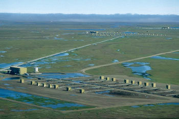
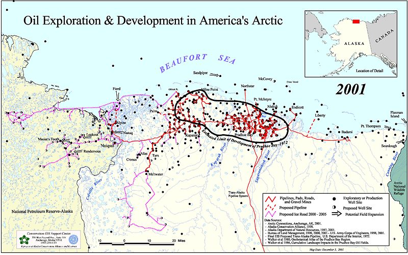
Prudhoe Bay is the largest oilfield in North America, measuring approximately 15 miles by 40 miles. It is located in northern Alaska on the coast of the Arctic Ocean.  The main Prudhoe Bay field has a number of adjacent 'satellite' oilfields, some of which are Kuparuk ("Kuh-PARR-uck"), Endicott, Point MacIntyre, Milne Point, and Niakuk ("NY-uh-kuck".) 

The two major oil producers in Prudhoe Bay are BP (British Petroleum) and Phillips (formerly ARCO).  In addition, there are about five other oil companies with a financial interest.  Prudhoe Bay and its associated fields produce nearly 1 million barrels (42 million gallons) per day.  The area has produced approximately 15 billion barrels (630 billion gallons) of crude oil in its 25-year history, or nearly one-fifth of U.S. consumption.

I'm Gary Hoefs, a student at the University of Minnesota Duluth.  I worked in Prudhoe Bay for two years before returning to college.  Since most people will never have the chance to visit this amazing place, I'll do my best to describe it for you as I remember it.

  overview of a drill site

Drill site at Prudhoe Bay. The smaller structures are wellhouses sheltering the wellheads from snow. The larger structure at left is a manifold building that controls the production at that drill site.

 
Prudhoe Bay is often called the 'North Slope' which refers to the region at large.  The name doesn't really fit, as the landscape is billiard-table flat.  The name is actually derived from the Brooks mountain range about 100 miles to the south. The North Slope is entirely covered in permafrost, a condition where the soil about two feet down from the surface remains in a permanently frozen state. The permafrost, combined with the flatness of the land, results in an abundance of small lakes and ponds, because spring snow melt has nowhere to go. (This in turn, means ferocious swarms of mosquitoes in the summer!) 
The oil itself lies in porous rock formations anywhere from 5,000 to 20,000 feet below the surface. It rises to the wellhead under its own geologic pressure, so no pumping is required. Produced oil normally comes up mixed with water, natural gas, and even paraffin wax crystals. Therefore, oil from all the wells on a given drill site or pad (usually 20-30 wells) is sent to a manifold building, which tests the production for the oil/gas/water ratio. The mixture is then sent to one of several flow stations / gathering centers, where the oil is separated out, and sent down the pipeline to market. All of the water and some of the gas is reinjected back into the ground to enhance the formation pressure. A fraction of the natural gas is used to heat all the buildings in Prudhoe Bay. The rest, an enormous amount, must simply be burned off. There currently* is no practical way to get that gas to market.

*Research and debate is under way right now in Alaska on how to ship the gas. Two of the main options include a new pipeline, and ways to liquefy the gas to send it down the existing pipeline. 

 
flow station flaring off natural gas
Excess natural gas being flared off.
 

forward to safety back to Prudhoe Bay home to Prudhoe Bay home

Other
Pump Stations: