Pass the mouse pointer over regions within a map to display different images.
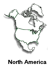
- The map of North America must be named. Click once anywhere in the white
space within the map rectangle (but not within the shaded area of North America)
- On the Properties Palette, type north_america into the text box located
just to the right of the map icon (below the word "Image".)
- Click once on the area of the map occupied by Alaska.
- Open the "Design" palette on the right, and choose the "Behaviors"
tab.
- Click on the plus-sign button to display a list of behaviors.
- Choose Swap Image.
- * Verify that the image name "north_america" is highlighted.
*Verify that the check boxes "Preload Images" and "Restore
Images onMouseOut" are both checked.
* Click in the "Set Source to:" text box, and type in the filename,
alaska.gif
- Click on the OK button to close the "Swap Image" window.
For each of the remaining regions (Greenland, Canada, "continental"
US, and Mexico), click on that region and repeat steps 5 through 8 for each
one, specifying for "Set Source to:" greenland.gif, canada.gif,
continental_us.gif, and mexico.gif.
When completely finished with all of the regions (map areas), click on the
"X" box to close the "Behaviors" window, and choose "File,
Save As..." to save the updated file with the file name "exampledone"
in your "exercises" folder. Then view the page in your browser to
see if your interactive map works.