Geology 3210
Fall 2009
Lab 12: Aeolian Features and Mars
This lab is designed to
be done from home as long as you have an internet connection, Google Earth, and
your textbook. It is due on Wednesday,
Dec. 2nd. Have a Happy
Thanksgiving!
For this lab, you are going to investigate different kinds of dunes, where they form, and what they tell us about dominant wind directions. To complete this lab assignment, you will need to find a computer running Google Earth. You can download it for free to your own computer: http://earth.google.com/. After you look at dunes on Earth and Mars, we’ll look at some other interesting features on Mars.
Refer to your textbook on p. 289 (similar figure from McKee (1979) attached here) for a picture of different kinds of dunes and the wind directions associated with them. You should also read through the section in dunes from p. 286-292.
Background. Prevailing winds and locations of deserts
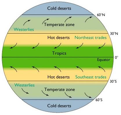
Around the world, prevailing winds are organized into cells based on latitude. Warm, moist air rises at the equator, and cool air sinks at ~30° N and S latitude. This drives the Hadley cells. The same kind of pattern sets up in the higher latitudes, too, with the Ferrel cells between 30° and 60° and the Polar cells between 60° and 90°. Most of the world’s deserts are found where dry air sinks: around 30° N and S and at the poles. (Note: You can find deserts elsewhere, too, due to local effects from rainshadows, etc.)
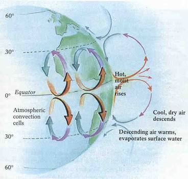
Because the Earth is turning, the Hadley cells have a general easterly direction to them (start in the east and blow west), leading to the northeast and southeast trade winds. From 30° to 60°, you find the westerlies (blow from west to east).
Where are we
located? What is the prevailing wind direction
here?
Although these are the prevailing wind directions, local topography and locations of features like oceans and lakes can alter local patterns of winds.
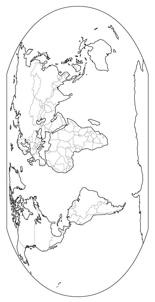
Print out a copy of the map of the world. Sketch in the prevailing wind directions.
I. Dunes on Earth.
Open up Google Earth. Zoom around the globe and locate dune fields in at least 8-10 different locations – try to spread them out around the globe.
For each dune field describe what you see, what kind of dunes are present, and what it tells you about the dominant wind direction. Include a sketch. Is the dominant wind direction derived from local features, or from the overall prevailing wind patterns?
Add to your map A) the kind(s) of dunes found at each location and B) the dominant wind direction indicated by the dunes. You should include a key indicating what kinds of dunes are present. In some cases, the wind directions will coincide with the prevailing wind directions. In other cases, wind directions will be dominated by local effects. Consult your book on p. 289 for dune types (or see here).
Part II. Wind Activity on Mars
This part of the lab will involve a comparison of aeolian features on the Earth and on Mars. We will also look at other cool features on Mars, because why go there if you can’t look around.
Dunes
· Launch an internet browser and go to http://www.google.com/mars

· Clicking and dragging the mouse will allow you to “travel” on Mars
· Make sure you check out the infrared band (upper right corner) – this is the best resolution!
Remember those two rovers that went up to Mars several years
ago? They are still there, and they are
still running. Let’s go find them. The latest updates can be found here: http://marsrovers.nasa.gov/home/index.html.
1. What evidence so
you see for aeolian activity here?
Spirit is in Gusev crater. Search for Gusev crater. (Type in “Gusev crater” on Google Mars) at the top, just like a regular Google search. Make sure you have the “infrared” layer highlighted. This high-resolution image was taken by THEMIS. Zoom in around the green and red pushpins and take a look around.
2. What evidence do
you see for aeolian activity here? What
is the wind direction?
Play around in the sand dunes here: http://themis.asu.edu/theme-sand_dunes
3. Are these dunes
similar to dunes on Earth? Find 3
examples of dunes that you found in Google Earth. Sketch them and list their location on Earth
and Mars. Indicate wind direction.
·
Have you ever seen a dust
devil? See them on Mars!!

http://marsrovers.jpl.nasa.gov/gallery/press/spirit/20070412a.html
·
![]()
![]() Search
for “Tikhonravov”, zoom into here, and describe what you see
Search
for “Tikhonravov”, zoom into here, and describe what you see
between the two craters. Can you find the layered stratigraphy?
Also look here: http://images.spaceref.com/news/2005/2005.06.23.S0401142.gif
4. What are some ways
you can you form layered stratigraphy?
Part III: More on
Mars
Since we went all the way to Mars, we should check out a few other interesting features while we are here. These last few questions area adapted from an exercise put together by a Mars expert, Sanjoy Sam, and should give you a nice picture of some of the cooler features of Mars.
Let’s go to
Type “Olympus Mons” in the search bar and zoom in.
5. How many calderas
can you see at the summit (you might have to go into infrared mode)?
5. How many eruptions
did
Find the escarpment on the western flank of
Past water
Mars today cannot sustain liquid water on its surface
6. Search for “Apsus
Vallis”. What can you see? What does
that imply for the history of water on Mars?
Look at more cool pictures of Mars “rivers” here: http://themis.asu.edu/theme-channels.
Search for “Kasei” and zoom out a little bit for perspective. Kasei Vallis is a valley.
7. Can you find
evidence for water flow on the surface?
Sketch what you see. In which
direction did the water flow?
Some of the best evidence for persistent, flowing water on Mars comes from a distributary delta system found in NE Holden Crater: http://www.msss.com/mars_images/moc/2003/11/13/
8. The distributary
channels are now exposed as linear ridges.
How could this happen?
Canyons
Search “Vallis Marineris”, the biggest canyon in the solar system!!
9. How deep is it?
(hint: look at the height legend on the “Elevation” view). The Grand Canyon in
Switch to the infrared layer. Look just north of the red thumbtack labeling Vallis Marineris.
10. What is happening
to the canyon walls through time?
You can actually fly through Vallis Marineris here: http://video.google.com/videoplay?docid=-1622667251598627943
Other amazing images
·
High
Resolution Stereoscopic Camera, Mars Reconnaissance Orbiter: http://hirise.lpl.arizona.edu/katalogos.php
· Mars Orbiter Camera, Mars Global Surveyor : http://www.msss.com/msss_images/index.html
· Themis: http://themis.asu.edu/