Near-Inertial Coastal Experiment (NICE; NSF)
During the summer of 2017, collaborators from UMD, Scripps Institution of Oceanography, and Oregon State University deployed 20 moorings in the western arm of Lake Superior to measure wind-driven internal waves and turbulence. Collaborator Drew Lucas deployed ten moorings that had state-of-the-art wave-powered profilers, known as Wirewalkers. By the end of the summer, these profilers had collected close to 30,000 profiles between the surface to 60 m depth. Data analysis and modeling work for this project are ongoing.
In addition to the moorings, several 24-h shipboard surveys collected transects of temperature, turbulence, and florescence in the lake. Below, a plot shows four transects of temperature (deg C) transects between Grand Marias MN (left) and Ontonogan MI (right) from August 2017. The abrupt depressions in the surface layer near 47.4 N in the top panel, indicate large subsurface waves in the lake.
The NASA SWOT mission
In April 2021, NASA and CNES will launch the Surface Water and Ocean Topography (SWOT) satellite. The satellite will measure ocean and lake levels using a 120-kilometre-wide swath radar altimeter. Over the ocean, the satellite will measure ocean currents and swirling eddies at scales as small as 20 kilometers. Over the continents, the satellite will precisely measure the heights of most rivers wider than 100 m and most lakes larger than 250 m x 250 m.
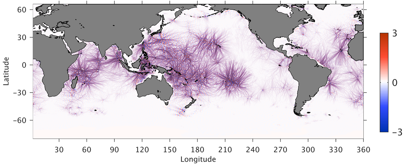
One of the mission goals is to remove ocean elevations due to internal waves at the tidal frequency. Because the satellite only repeats its track every 21 days, each measurement will see a different phase of the tide, and highly-accurate global models are needed to estimate and remove the tidal signals. Below is a global simulation of internal tide surface elevation (in centimeters). The plot appears "purple" because the internal tide crests and troughs are only about 150 km apart. The waves radiate away from large underwater ridges (like Hawaii), where surface tides (i.e., conventional tides) flow up and over steep slopes.
My specific activities on this project are described here.
Tasmanian Tidal Dissipation Experiment (NSF)
Ocean tides not only raise and lower the sea-surface, they also create horizontal currents that flow back and forth. Where these currents encounter steep topography (like mid ocean ridges), they are deflected and produce vertical currents, which create subsurface waves at the interface between the warmer (less dense) surface water and colder (more dense) deep water. These subsurface waves, which are sometimes hundreds of meters tall, are "internal" to the ocean and have the same frequency as surface tides, so they are often called "internal tides".
Globally, tides lose about 70% of their power (3.5 TW) in shallow seas due to bottom friction and about 30% of their power (1 TW) in the deep ocean to the generation of internal waves. The energy loss in the deep ocean is particularly important because internal tides may break (like surface waves), mixing warm surface water downward and affecting how the ocean stores and transports heat.
A decade ago, the Hawaiian Ocean Mixing Experiment (HOME) provided a comprehensive look at the internal tide generation process. Now, the Tasmanian Tidal Dissipation Experiment (T-TIDE), Tasmanian Tidal Beam Experiment (T-Beam) and Tasmanian Continental Shelf Experiment (T-Shelf) aim to study the rest of that life cycle by providing the first comprehensive observations of an internal-tide beam as it propagates through the open ocean before dissipating and/or reflecting from a continental slope. These innovative experiments are largely funded by the National Science Foundation, although T-Shelf is supported by the Australian Research Council and the Schmidt Oceans Institute provided 27 days of ship time aboard the R/V Falkor.
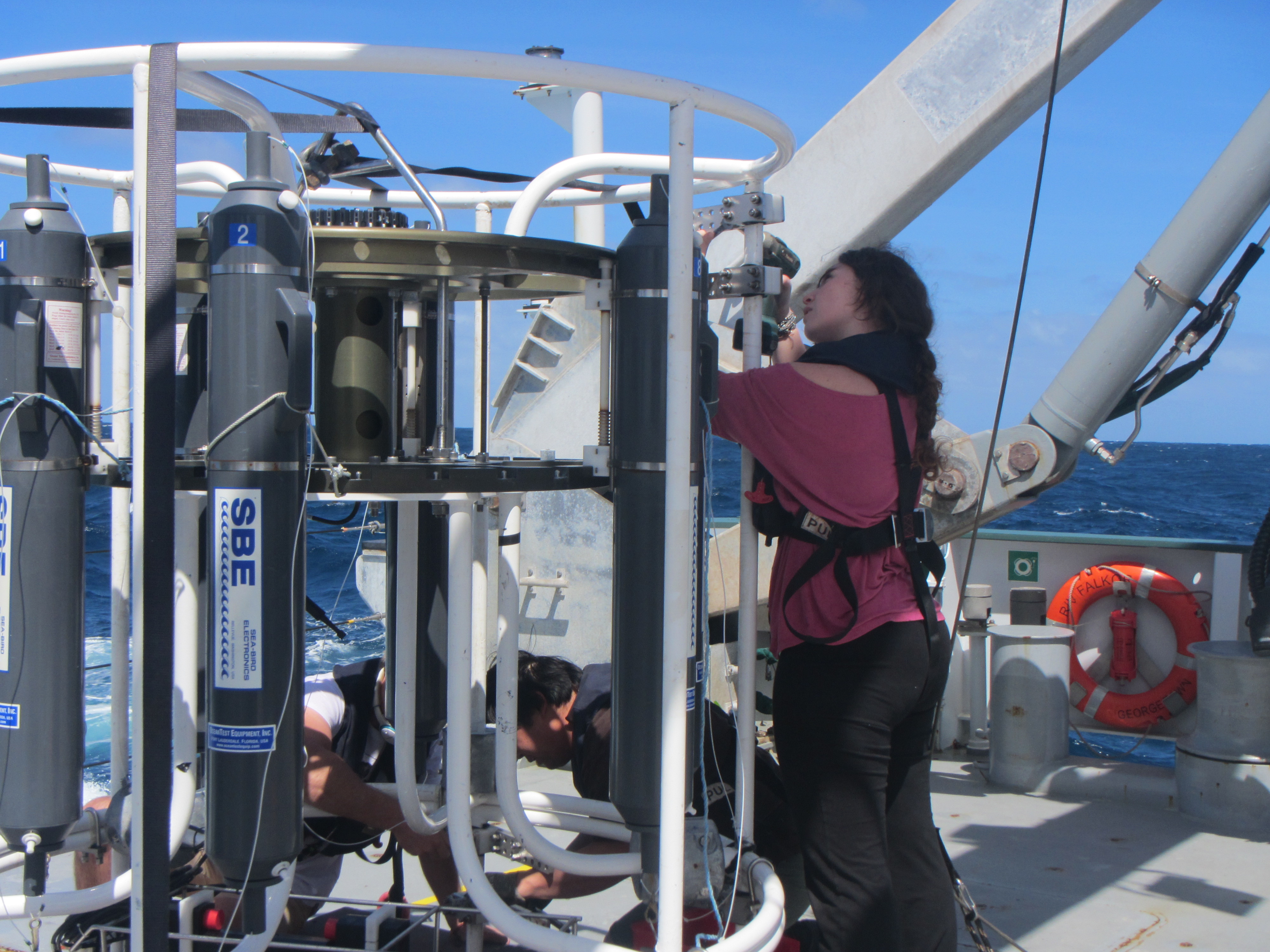
The experiments were set in the Tasman Sea, where internal waves are generated at the Macquarie Ridge, an underwater mountain range that extends southwest of New Zealand and is similar in size to the Rocky Mountains. Once generated, these internal waves propagate 1,000 km northwest and strike the island of Tasmania. In January 2015, after several years of preparation, we collected intensive observations of these internal waves using two research vessels, autonomous underwater gilders, and numerous moorings. The fieldwork and some initial discoveries are discussed at the T-TIDE website, which includes lots of cool photos and videos.
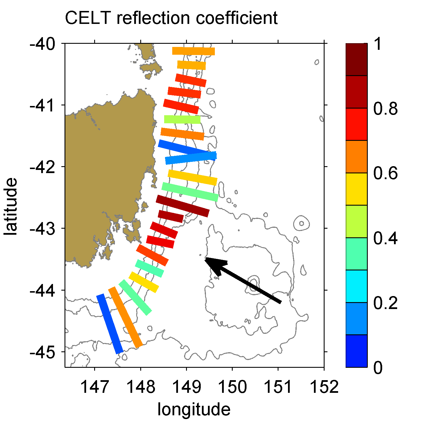
A recent paper combining glider observations and the CELT numerical model, suggests that a large fraction of the internal tide's energy is reflected at the Tasmanian continental slope:
T. M. S. Johnston, D. L. Rudnick, and S. M. Kelly, (2015), Standing Internal Tides in Tasman Sea Observed by Gliders, J. Phys. Oceanogr., 45, 2715-237, doi:10.1175/JPO-D-15-0038.1.
Past fieldwork
I've had the privilege of participating in numerous field projects, which have involved 19 research cruises in four countries aboard nine different vessels. The following list gives the location, chief scientist(s), research vessel and duration of each cruise.
Lake Superior, Minnesota (2020), S. Kelly, Recovered 3 moorings and redeployed 1 mooring, R/V Blue Heron, 3 days.
Lake Superior, Minnesota (2019), S. Kelly, Recovered and redeployed 3 moorings, Profiled microstructure from the ship, R/V Blue Heron, 5 days.
Lake Superior, Minnesota (2018), S. Kelly, Recovered and redeployed 3 moorings, Profiled microstructure from the ship, R/V Blue Heron, 9 days.
Lake Superior, Minnesota (2017), S. Kelly, Recovered 23 moorings, deployed 13 moorings, Profiled microstructure from the ship, R/V Blue Heron, 24 days.
Lake Superior, Minnesota (2016), S. Kelly, Recovered and redeployed 3 moorings, R/V Blue Heron, 2 days.
Lake Superior, Minnesota (2015), K. O'Malia and S. Kelly, Recovered 4 moorings and redeployed 3 moorings, R/V Blue Heron, 3 days.
Tasman Sea, Australia (2015), A. Waterhouse and S. Kelly, Measured conductivity, temperature, and velocity (i.e., CTD/LADCP) from the ship, R/V Falkor, 27 days.
Lake Superior, Minnesota (2014), S. Kelly, Profiled microstructure from the ship, R/V Blue Heron, 4 days.
Lake Superior, Minnesota (2014), J. Austin, Recovered 3 moorings and deployed 4 moorings, R/V Blue Heron, 4 days.
Lake Malawi, Malawi (2014), E. Brown and S. Katsev, Recovered and redeployed 2 moorings, R/V Ndunduma, 4 days.
Australian North West Shelf (2012), R. Brinkman and J. Book, Recovered 18 moorings, R/V Solander, 14 days.
Australian North West Shelff (2011), J. Luetchford, Deployed a mooring, R/V Solander, 2 days.
Australian North West Shelf (2011), J. Luetchford and N. L. Jones, Recovered and redeployed two moorings, R/V Solander, 3 days.
Mediterranean outflow, Spain (2009), J. D. Nash, H. Peters, and J. Pelegri, Deployed and recovered two moorings; and measured conductivity, temperature, and velocity (i.e., CTD/LADCP) from the ship, B/O Garcia del Cid, 10 days.
Oregon continental shelf (2009), J. N. Moum and J. D. Nash, Deployed and recovered four bottom landers and profiled microstructure (turbulence) from the ship, R/V Wecoma, 9 days.
Oregon continental shelf (2007), J. Barth and M. Levine, Deployed a mooring, measured conductivity and temperature from the ship, and performed diagnostics in the development of a moored profiler, R/V Wecoma, 3 days.
New Jersey continental shelf (2006), J. N. Moum, Profiled microstructure from the ship, R/V Oceanus, 28 days.
Yaquina Bay, Oregon (2006), G. Avicola, J. N. Moum, and J. D. Nash, Recovered bottom landers and profiled microstructure from the ship, R/V Elakha, 2 days.
Columbia river plume, Oregon (2005), J. D. Nash, Profiled microstructure from the ship, R/V Point Sur, 26 days.